This is part two of Heather and Chris Hartridge’s bicycle tour through Washington state.
After a few days soaking up the sun and swimming in the clear waters above the Grand Coulee Dam we hit the road early. Our route would take us south along Banks Lake, down to the small agricultural community of Coulee City. If we didn’t arrive before noon we risked extending our ride into the super hot afternoon sun. This area is either irrigated fields or pure sagebrush desert.
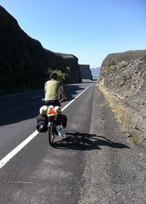
Banks Lake follows the Grand Coulee, created by the Missoula Floods 15,000 years ago. At the end of the last Ice Age, a huge natural dam held back the melting waters until it let go with dramatic results. It scoured out huge areas of present-day Montana, Idaho and Washington. Today, massive basalt facades rise up from the floor of the valley. One gargantuan monument is called Steamboat Rock and is like cycling next to an ocean liner.
Riding on a bicycle gives you a chance to see the smaller things as well. Rattlesnakes crossing the road, birds of prey feasting on the ones that didn’t make it across and desert mice are part of the food chain here. Monarch butterflies have found a temporary home and huge grasshoppers... or maybe they’re locusts? ... are residents we meet.
Part way down the lake there is a section of the road called the “Million Dollar Mile.” We’re pretty sure B.C.’s Sea to Sky Highway has surpassed this icon of engineering but in the 1940s it was a big deal. The mile takes us up and through a cut in the basalt. On our bikes we have a close up view of the geology that represents the formation of this valley. Each layer of volcanic rock or basalt columns represent a major eruption eons ago. It’s all quite amazing.
Just down the road, Coulee City is a grassroots town boasting both a Case and John Deere tractor dealership. The wheat fields around here are huge and keep the machinery and chemical companies busy. Like parts of Canada, this region of Washington has witnessed a major shift in the farming culture over the years. Family farms have been replaced by large companies using all the latest technology, albeit genetically focused and chemical dependent.
After an overnight stay in the community campground, we left Coulee City to ride west through the unnervingly perfect farmland towards the Columbia River. We left town at 5 a.m. so we could get most of riding in when it was cool. Riding up out of the coulee with the sunrise behind was one of those special moments we’ll remember for a long time. It wasn’t long before we dropped back down into another valley called Moses Coulee. Appropriately named, its biblical proportions are staggering, particularly from a bike. We stopped dead centre of the coulee for some food and water and could feel the sun’s rays gaining steam. “Can’t stay here long,” we said to each other. We had been riding for 2.5 hours already and were not quite a third of the way to our destination, the city of Chelan. We continued riding past deserted homesteads and the remains of towns that were once vibrant communities. As I was riding, I thought it would be a great idea for some talented photographer to put together a photo essay of the changes to rural communities both here and in Canada. Then I realized, somebody must have put that together already. I wonder?
This is one of those places where riding a bicycle can be hazardous. Passing tractors in the fields were tilling the soil and dispensing something that had an unfamiliar chemical aroma that took our breath away. We pedalled as hard as we could to get out of there.
After 7.5 hours of riding it became abundantly clear that we had been climbing slowly but steadily all morning. At 12:30 p.m. we arrived at the summit of McNeil Pass.
“Did you know there was a pass?” “Nope, wasn’t on the map.” The good thing about passes is there is always a ‘down’ side. In this case it was 10 kilometres down at 12 per cent grade. “That’s almost straight down!” It was nothing short of thrilling. We weren’t keeping track but it seemed to only take a few minutes and we were at the bottom next to the Columbia where the temperature was at least 36 degrees Celcius! What a change from up top.
On our way to Chelan we passed by fruit co-op packing houses where the shifts were just changing during this high-production time. We made our way to Chelan’s very busy community campground and decided we had earned a well-deserved cold beer. We melted into the cool green grass of the campground and had our “tall cool frosty one” under the shade of a huge maple tree. It had been a long day – 9.5 hours of riding covering 95 kilometres. Tonight would be another one night stay as we were headed to the the oasis called Stehekin, 55 miles away at the western end of Lake Chelan. Our ferry would leave at 8:30 the next morning.
The scene at the ferry terminal was one of excitement and the usual jostling for position. The village of Holden is en route and is a very popular destination for people of the Lutheran faith. Holden used to be an active copper mining town but is now a retreat for anyone wishing to experience the solitude of the North Cascade Mountains around this small settlement. There are no cars on this ferry only foot passengers and gypsies like us wanting to take our bikes on board. As it turned out, the majority of passengers waiting for the ferry were on their way to Holden. The ferry also makes stops to drop off hikers at trailheads into the Cascades.
The four-hour ferry ride was relaxing. In stark contrast to our ride the day before, we cruised through this inland fjord taking in the alpine scenery all around us. The captain of the ship was very courteous and advised those of us standing near the bow to plug our ears. Hooooot! The ship’s horn announced our arrival. Unloading was quick and within minutes we were on our way to a beautiful (and free) National Park campground on Lake Chelan.
Stehekin is a native term for “The Way Through.” For centuries, this area has been the chosen route between the coastal communities of the Puget Sound area and the inland dry lands on the east side of the Cascades. Today’s Stehekin is dependent upon the U.S. National Park Service, tourism and the resourceful nature of the people who live here year round. In the late 1800s, when land to settle on was becoming more scarce west of the Cascades, hardy settlers came here to carve out a future.
Descendants of those settlers still live in the area. Much like our hometown of Quesnel, around 40 years ago a new breed of settlers came here to take their turn at living close to the land. Carl, who runs a magnificent organic market garden, is one of those people. We spent some time in Carl’s garden and left with a big bag of veggies for our dinner. The locally-owned bakery is also a must for those with a sweet tooth and a hankerin’ for a really good cup of coffee. And a visit to the Buckner Orchard is well worth the time.
The Buckner’s were among the first people to settle in the Stehekin Valley and make a living from the land. The valley is blessed with water fed from lakes high in the mountains and their orchard was an example of low-tech ingenuity. The irrigation system is a series of small channels that transport water from a nearby river direct to the roots of the trees. Amazing!
The rest of our time here we spent lolling on the shore of the lake, taking the occasional brazen dive into the numbing waters. Lake Chelan is not far from the largest concentration of glaciers in Washington. It’s a great way to wake up! Oh, and to all our friends who are adept with canoes and kayaks, you’ll be pleased to know we also jumped ‘out of our box’ and took a short kayak trip to the other side of the lake from our campground. We were going to see some ancient pictographs on a rock face rising out of the lake. Unfortunately, well into the journey the wind reached what seemed to be near gale force, resulting in waves that were unfairly huge. To top it off, the two-man Ship of Fools we rented would have been far better off as a cute garden planter in front of the office where we picked it up. I decided this when the water started to roll in over the side unannounced and uninvited. Ready to yell “man overboard!” at a moment’s notice, we balanced the Good Ship Lollipop around the edge of the Lake and were rewarded with a brief, albeit rewarding, glimpse of a group of unsuspecting sheep being pushed off a cliff over 1500 years ago. “Did ya see it?” “Yes?” … “Good!” Pointing the bow of our plastic bucket into the wind, we safely navigated back to port, oh so ready to jump on our bicycles.
Our trip will now take us north through the apple orchards towards the border. We’ll see what unfolds.
Chris Hartridge is a biking enthusiast and regular Observer contributor.