The BC Wildfire Service (BCWS) has added fire perimeter maps to some fires in the Baezaeko Complex, as well as a larger map showing the locations and sizes of all four Wildfires of Note in the Baezaeko Complex.
The Blackwater River Fire and Shag Creek Fire both now have perimeter maps showing the outline of the fire.
“These maps are mostly for the public,” says the Baezaeko Complex incident management team’s fire information officer Ellie Dupont.
“It’s so people can see clearly what the situation is on the fire.”
Dupont notes that the fire perimeter map available for the Shag Creek Fire is currently still an estimate as crews have not yet been able to accurately map the fire.
In addition to these maps being released to the public, the Baezaeko Complex incident management team now has 14 helicopters on site to share between all four fires in the complex, up from 11 previously.
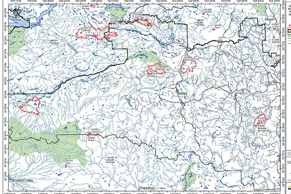
| A map showing the perimeter of the Blackwater River Fire. BC Wildfire Service map |
The Blackwater River Fire is still currently listed at 6,619.9 hectares and zero per cent contained.
A successful burn operation occurred yesterday along the western flank to the Nazko River. Structure protection specialists are conducting assessments along Nazko Road south of the fire as well.
“The Blackwater River Fire had a successful burn off yesterday and the crew is happy with the result of it and feel it is hopefully going to stay that way until we can get a further guard and can call it contained. They were able to put a contingency line on it yesterday. They will finish that today or tomorrow,” says Dupont.
“A contingency line is the line outside of the perimeter of the fire which is about the width of two excavator tracks,” explains Dupont, saying they only back burn from that contingency line if the fire extends over its perimeter.
Dupont says there will be more hand ignitions on the east flank of the fire today to reinforce what has already been done, and then they will mop that up with bucketing and digging.
She says the fire operations chief went up in a helicopter to check the size and perimeter of the Blackwater River Fire after it increased in size yesterday.
“We were told the evacuation order would not be expanded,” says Dupont.
There are 29 firefighters and 11 pieces of equipment on site.
WATCH: Air Quality Rating back up to very high risk in Quesnel
The North Baezaeko Fire, located 85 kilometres west of Quesnel, has increased in size from 4,650 yesterday to 5,002.5 hectares.
There are actually two fires in this area which are being treated as one for ease of management, although they have not merged.
“The North Baezaeko Fire has moved closer to Nazko over the last few days but has not reached the trigger point to cause an evacuation order to be broadened,” says Dupont.
The fire is still zero per cent contained.
“Crews continue to build guard along the northeast flank. They will mop-up the excursions in the southwest. The crews will continue with hand ignitions to the guard on the south flank. This is when the crews are burning small green areas of available fuels to reinforce the guard,” says the BCWS website.
A burn operation yesterday successfully eliminated green fuels to minimize further wildfire spread.
The North Baezaeko Fire has 50 firefighters and 13 pieces of heavy equipment.
The Narcosli Creek Fire remains listed at 3,414.6 hectares, 50 per cent contained ant 90 per cent guarded.
A planned burn was executed on the fire yesterday to help eliminate green fuels.
“An assessment for opportunities to build wide contingency machine guards in the south and southeast is also a current objective,” reads the most recent BCWS post.
There are 91 firefighters (up from 74 yesterday) and 22 pieces of heavy equipment on site.
And the estimated size of the Shag Creek Fire has reduced from 10,200 hectares yesterday to an estimated 9,563 hectares. The fire remains zero per cent contained with no crews on site. The fire is being monitored by air, says the BCWS.
| A map showing the estimated perimeter of the Shag Creek Fire. BC Wildfire Service map |
There are currently still 11 active wildfires burning in the Quesnel Fire Zone. There are one fire is Being Held, three fires are Under Control and seven fires in Out of Control status.
The Yuzkli Lake fire is south of Big Valley Creek and estimated at 100 hectares, up from 32.5 hectares yesterday. Heavy equipment is building guard in areas that are accessible; however, there are areas with steep terrain that are not able to be accessed.
The fire west of Mustang Lakes is still estimated at 123.5 hectares. There are eight ground personnel on site, says the BCWS.
And just north of the border of the Cariboo Regional District, the Chutanli Lake Fire is now listed at 14,696 hectares, up from 13,371 hectares. The fire is in the Prince George Fire Centre but has extended over the border into the Cariboo and evacuation alerts and orders are in effect throughout the area. The fire is 23km west of Titetown and 1-2 km west of Batnuni.
The fire remains out of control. There are 86 firefighters and 25 pieces of equipment on site.
Poor visibility is affecting the use of aircraft today, says the BCWS.
“As such, additional structural protection crews will move into Batnuni today and stand-by should they be required. Cooler temperatures and slightly favourable winds will reduce the risk of erratic fire behaviour; however, increased winds are predicted for this evening,” reads the latest update.
Crews are monitoring and mopping up, where safe to do so. There is also work being done to install guards around the head of the fire on the west side continues.
READ MORE: Update on wildfires in the Cariboo, Aug. 22
editor@quesnelobserver.com
Like us on Facebook and follow us on Twitter