All buses are running again today, Friday, Jan. 17, in the Quesnel School District.
As recorded at 5 a.m. at the airport, the temperature in Quesnel right now is -27 C.
While we aren’t seeing the extreme cold temperatures we saw earlier this week, there does continue to be a risk of frostbite.
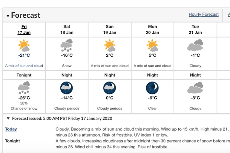
Environment Canada’s forecast for Quesnel calls for a mix of sun and cloud this morning and winds up to 15 kilometres per hour. The wind chill is expected to be -33 C this morning and -28 C this afternoon, with a risk of frostbite. Today’s high is -21 C.
For tonight, the forecast is for a low of -26 C and wind chill of -34 C, with a risk of frostbite. Expect increasing cloudiness after midnight and a 30-per-cent chance of snow before morning.
The temperature is a bit colder in Nazko this morning, at -29 C (which, according to The Weather Network, feels like -33 C), while the temperature in Wells this morning is -26 C, although The Weather Network reports that feels like -32 C.
In Nazko, the temperature is expected to get a bit higher, to -24 C today, with mainly sunny skies and cloudy periods in the afternoon, and then it will drop to -30 C this evening, and the forecast calls for it to be partly cloudy, with a 40-per-cent chance of flurries.
For the rest of the day, the forecast for Wells is for cloudy skies with a few flurries ending in the morning, partly sunny skies in the afternoon, and -21 C. This evening will be mainly clear, with cloudy periods and flurries developing overnight, and the temperature will drop to -26 C.
In Quesnel, temperatures are supposed to start climbing tomorrow, as Environment Canada calls for a high of -16 C and low of -14 C Saturday, with two to four centimetres of snow. The wind chill is expected to be -27 C in the morning and -22 C in the afternoon.
The forecast calls for a high of 2 C and low of zero Sunday, then a high of 5 C and low of -6 C Monday and a high of -1 C and low of -8 C Tuesday.
Looking farther ahead, Nazko’s forecast calls for -19 C on Saturday but then warmer temperatures after that, with -4 C on Sunday, -1 C on Monday and -3 C on Tuesday.
The Weather Network shows temperatures in Wells getting above zero by early next week, and the forecast is calling for -7 C on Saturday, -1 C on Sunday, 2 C on Monday and zero on Tuesday.
READ MORE: Quesnel breaks 100-year-old temperature record amid winter storm
editor@quesnelobserver.com
Like us on Facebook and follow us on Twitter