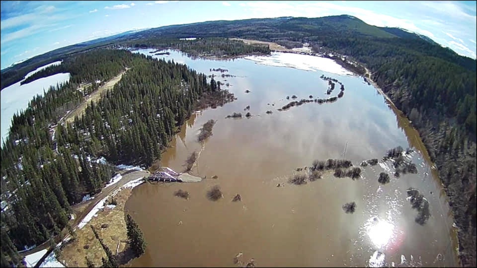
With a quick change to warm temperatures increasing the snowmelt rates, spring flooding has been affecting many roads in our region.
On Tuesday, April 21, the B.C. River Forecast Centre maintained a Flood Warning that had been issued the day before for the Nazko River and West Road River and upgraded to a Flood Warning for the Cariboo and Chilcotin (Fraser Plateau), including tributary rivers and streams around Williams Lake, Quesnel, Alexis Creek, Anahim Lake, Cache Creek and surrounding areas.
The River Forecast Centre also maintained a Flood Watch for tributary rivers and streams around Chilako and south-west of Prince George.
A Flood Warning means river levels have exceeded bankfull or will exceed bankfull imminently, and that flooding of areas adjacent to the rivers affected will result, and it is the highest level of warning issued by the River Forecast Centre.
A Flood Watch is the intermediate level, and it means river levels are rising and will approach or may exceed bankfull. Flooding of areas adjacent to affected rivers may occur.
“Cold spring weather over the past month has transitioned to climbing temperatures over the past several days throughout the B.C. Interior,” the River Forecast Centre’s advisory states.
“Daily maximum temperatures over the past few days has been in the in 10-19 degrees Celsius range in Williams Lake and Prince George and up to 24 degrees Celsius around Cache Creek, compared to the sub-zero daily maximum temperatures that persisted earlier in the month.
“Snowmelt rates have increased, with reports that the rapid transition in temperatures may be playing a factor in increased overland flow due to frozen ground conditions and ice-jamming. River levels have been rising rapidly, with high flows being observed in small tributary rivers and creeks throughout the Interior Plateau from Cache Creek north through Williams Lake, Quesnel and west across the Chilcotin.”
As of 6 a.m. Tuesday, April 21, the West Road River near Cinema was flowing at an estimated 430 cubic metres per second, which is a 20-year flow, and rising, while Baker Creek at Quesnel was flowing at 85 cubic metres per second, which is between a five-year and 10-year flow, and rising.
The public is advised to stay clear of the fast-flowing rivers and potentially unstable riverbanks during the high-streamflow period.
On Friday, April 17, Emcon Services Inc. cautioned Quesnel and area residents that some of Emcon’s service area is starting to experience water coming across the road or fully covering the road.
“Do not drive through areas of standing water if road is covered,” Emcon states. “Road could be damaged under the water and is a safety risk to you.”
Drivers are asked to call 1-866-353-3136 if they notice water is starting to reach the road.
Since that advisory, Emcon has been very busy dealing with flooding on local roadways.
McLeese Lake and Hixon
On Saturday, April 18, Emcon responded to water covering the road on Highway 97 between the Beaver Lake Road intersection and Robertson Road in McLeese Lake, which resulted in single-lane alternating traffic.
Water covered the road at this spot again on Monday, April 20, resulting in single-lane alternating traffic, and as of Tuesday morning (April 21), the highway was still single-lane alternating traffic.
North of Quesnel in the Dunkley area, water was flowing over the road on Highway 97 between Naver Road and VanBuskirk on April 20.
As of Tuesday morning (April 21), there was still flooding, and Emcon reported that one lane was closed.
As well, a washout between 1500 Road and Mountain Road closed Pedley Lake Road in Hixon Tuesday, April 21.
Nazko Road
Nazko Road 10 kilometres north of Nazko was closed April 18 due to flooding, and Emcon says Harrington Road can be used as a detour and urges motorists to drive with care. DriveBC is reporting the road is still closed, and an assessment is in progress, as of Tuesday, April 21.
Quesnel-Hydraulic Road
On April 18, Emcon also dealt with a landslide on Quesnel-Hydraulic Road at the 20-kilometre marker.
Starting Tuesday, April 21 at 10 p.m., the Ministry of Transportation and Infrastructure is closing Quesnel-Hydraulic Road at kilometre 20.3 due to ongoing land instability, during the evenings.
“The site will be closed every night from 10 p.m. to 6 a.m., until our geotechnical engineers have determined it’s safe to re-open full-time,” according to a post on the ministry’s Facebook page. “Upon re-opening every morning, Emcon Services will monitor the area and make any necessary repairs to ensure the road is safe for the travelling public.”
A detour route via 2700 Road and 500 Road is being prepared to ensure there is always a route open to the public. Daily updates will be posted on DriveBC.
Milburn Lake
There has also been flooding in the Milburn Lake area.
Resident David Law says Milburn Lake overflowed Milburn Lake Road and flooded three neighbouring properties during the night of April 20.
He says he has never seen the lake this high in the 42 years he has lived here, and the overflow culvert is running “full bore,” but it is not large enough to cope with the increased volume of water.
Emergency preparedness
The Cariboo Regional District (CRD)’s Emergency Operations Centre (EOC) is activated at Level Two to enable a quick response to any flooding and to support residents who may be impacted by flooding.
The CRD is encouraging residents to take steps to be prepared for flooding.
“It is the homeowner’s responsibility to undertake temporary and sufficient flood protection to protect homes and property,” the CRD states in an April 19 news release. “Have an emergency plan, prepare emergency supplies, assess your property and buildings for potential drainage issues and take proactive steps to prevent flooding.”
Residents are encouraged to take these preparatory steps:
• Prepare personal emergency supply kits for your home, car and work (plan for at least a three-day supply of food and water for each family member)
• Have a grab-and-go kit ready if you must leave your home quickly
• Keep important papers in watertight containers and have a record of your valuables in a safe place
• If flooding is likely in your area, pay attention to the local media for information
• Watch for warning signs: increase in height and intensity of water flows, mudslides, debris in creeks, colour changes in water or leaning trees
• Know that banks of rivers and streams may be unstable and dangerous
• Keep a safe distance away from fast flowing water, especially children
• Teach your children about flood safety
• Consider arrangements for your pets and any livestock
• Learn more about proper sandbagging techniques at https://bit.ly/2XUnZGi
Residents are strongly encouraged to register for the Cariboo Chilcotin Emergency Notification System to receive a text, call or email regarding Evacuation Alerts and Orders or other emergency updates.
Register online at https://member.everbridge.net/index/453003085612292#/signup.
The CRD has made sand and sandbags available at the Bouchie Lake, Kersley and Milburn fire halls.
The McLeese Lake Volunteer Fire Department encourages anyone who is experiencing flooding of their properties due to the high water levels in the area, to phone the fire department, and they will send someone to assess the situation. According to an April 21 Facebook post, the fire department has pumps that may be of assistance, and sand and sandbags have been allocated for McLeese Lake by the CRD’s Emergency Operation Centre but have not arrived yet.
In the event of an emergency, call the CRD’s Emergency Information Line at 1-866-759-4977. To report a CRD-related emergency, call 1-800-665-1636 (after hours, press 5).
READ MORE: Update: Spring flooding wreaking havoc on Cariboo Chilcotin roads
editor@quesnelobserver.com
Like us on Facebook and follow us on Twitter