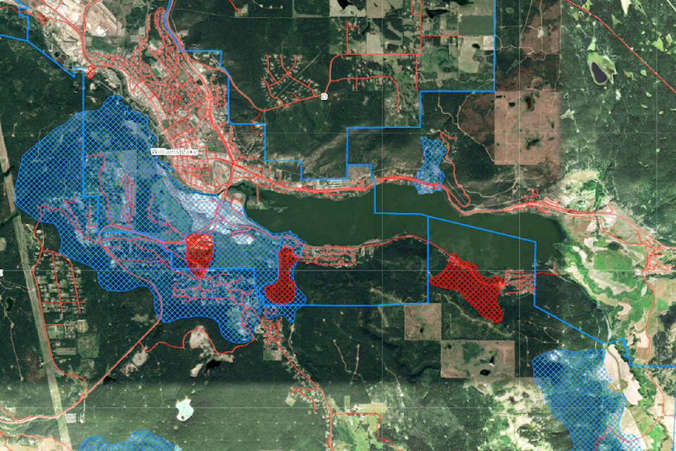
Large swathes of land on the west side of Williams Lake as well as outlying areas have been identified as “high hazard” and “moderate hazard” zones, according to a slope stability study released by the Cariboo Regional District (CRD) and City of Williams Lake Thursday, Sept. 29.
Areas in the active or recent high hazard red zone on the geotechnical hazard map includes portions of Dog Creek Road, Highway 20, Terra Ridge and the old college site as well as two areas on South Lakeside Drive.
Almost the entire west side of Williams Lake properties as well as some properties on the north side of the lake are in the blue zone - or ancient slide area, moderate hazard.
According to the CRD and city, the region is home to a number of historical landslide areas which are typically slow-moving slides that move progressively over a period of months or years.
“If you own property in or near one of the “slopes where the stability may be questionable” identified in the study, or if you are considering purchasing property in one of those areas, it is important that you educate yourself on the risks and on the methods to mitigate and avoid intensifying the issue,” notes the joint news release.
Williams Lake mayor Walt Cobb said he is not surprised by the report, but disappointed it does not offer any solutions.
“It gives us lots of information of what’s moved and what hasn’t moved, but it falls short of telling us how we might solve the problem. It leaves it up to individual property owners and says it is their responsibility.”
Anyone looking at building or renovating will have to make sure to get geotechnical people involved so not to cause more problems, particularly when it comes to movement of land or trees, Cobb added.
“Extra movement of trees or excavation for driveways can cause other issues as well. I know Terra Ridge had to do an extra retaining wall and we have had some phone calls from there asking what’s happening and if we have any answers yet.”
Cobb said the study is being sent out to property owners and council will receive the study to determine what to do next.
“Where do we go from here? When I hear what happened in Quesnel and the money they spent there and it’s still moving I think, maybe it’s not fixable.”
Getting a water and sewer system on Dog Creek Road could assist by removing some of the moisture in the ground, Cobb said.
“Everybody up there has lagoons or septic systems so the water is seeping into the ground. The water has to go somewhere. If we could divert that water it might alleviate some of the problems.”
CRD chief administrative officer said the CRD has been aware there are some properties that have been affected by land movement in the area,
“We did some analysis using LiDAR to make a comparison. It identifies some areas that are questionable slopes or areas that have been exhibiting movement.”
He cited along Dog Creek Road and Highway 20 as examples.
While this shifting land movement generally does not pose immediate risk or danger to life, it can cause significant damage to buildings, roads and other infrastructure, as has been the case on Dog Creek Road as well as a portion of Highway 20 in recent years.
To complete the analysis, geotechnical engineers used the LiDAR technology, which provides extremely accurate pictures of the Earth’s surface without any trees, plants or other vegetation. This technology allowed engineers to identify areas that have experienced appreciable land movement.
“It’s a snapshot in time,” MacLean said. “It’s a comparison of LiDAR that what we were able to fly here a few years ago. They accessed information as old as 2015.”
MacLean said all the information is used when residents are impacted whether it’s floods, fires or landslides and the CRD advocates on behalf of the electorate.
“We’ve been using this information in our conversation with government all along.”
Funded largely through the provincial government, the study will also go to the CRD board next for review.
“The board will have to look at the data, talk to our partners - the city of Williams Lake, the Williams Lake First Nation and the ministry partners that are still active in the area,” MacLean said. “The Ministry of Transportation has 10 active projects in the region right now related to landslide issues.”
MacLean noted the board will have to decide what options are available in terms of regulations and infrastructure and developing policy.
“The study is not predictive, meaning that it cannot predict how much the slides will move in the future,” stated the joint press release.
Those who are interested in reading the study, fact sheets or updates can review all documents at cariboord.ca/naturalhazards or williamslake.ca/942/natural-hazards.
Cariboo Regional District residents that have further questions can email landstability@cariboord.ca or call 250-392-3351 or 1-800-665-1636 and ask to speak to someone regarding the slope stability study.
Residents in the city of Williams Lake can email landstability@williamslake.ca or call 250-392-2311.
Do you have a comment about this story? email:
editor@wltribune.com
Like us on Facebook and follow us on Twitter.