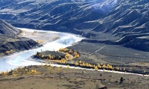
The Chilcotin River, near Riske Creek, is a deeply worn path showing the work of glaciers and melt water as it wears its way to meet the Fraser River which runs in a greater channel on its way to the tide water in southern B.C.
The area has been home to a band of big horn sheep for centuries where they labour in finding food in a very dry area where 10 in. (25 cm) of rain is a year’s total.
There are roughly 500 sheep, which are blue listed, in the 4,573 ha. park.
Near the edge of the Chilcotin River valley, before Farwell Canyon, a trail leads to the left through extensive grasslands, ending on a bluff with the view shown in the picture of the two rivers joining.
Grasslands were under some pressure as the forest, tree by tree, encroached on the openings. Grasslands have now been recognized as a vital and different feature. Cattle grazing also competed with the sheep and vehicle traffic rutted the grass areas as hunters, in the 1960s, looked for deer and upland game birds.
The idea, in that period up to the 1970s, of setting an area aside for the sheep caused considerable concern among many users as it would be a radical change in land management.
Harold Mitchell was a game biologist who worked for years to get some protection for the sheep as industry and agriculture grew in the area.
Art Downs, a Quesnel publisher (he started B.C. Outdoors which became Beautiful B.C.) and a leading member of the B.C. Wildlife Federation, in those days, worked and wrote tirelessly in support of the proposal.
Harold was killed while sheep counting, in a helicopter crash. As a result the reserve was created and a cairn can be found at the view point, as a tribute to his and others’ efforts.
The Quesnel and Williams Lake naturalists have led many to this area. The trail in is for pickups or high clearance vehicles. It is now the only access to this memorable spot, to admire the spectacle of rivers, grasslands, sheep, old placer gold tailings and the history of place.
The trail begins on a rancher’s property where the cooperative arrangement with Parks allows access.
Take a camera and wait for the light as Chris Harris does.
Andy Motherwell is an amateur historian and regular Observer columnist